


Now, when you think about London rivers, there’s one that comes to mind straight away… The Thames, right?
Well, in many parts of London you could be standing within inches of a lost river. There’s over 20 across Greater London… and this post is all about two of the City’s LOST rivers – the Fleet and Walbrook.
River Fleet
The source of the River Fleet is actually two springs in Hampstead Heath, which feed a series of ponds. Those springs come together in Camden Town and then flow under Kings Cross, down here past Farringdon before falling into the Thames under Blackfriars Bridge – as we will see later.
In Roman times, the Fleet was a major river, a hundred metres wide and bustling with mills, meat markets and hundreds of people.
People who filled the river with waste… human waste, animal carcasses, you name it. Imagine the stink!
You might think Fleet’s posh, but for many years it was known as ‘Fleet Ditch’ and was basically just a big smelly open sewer. Jonathan Swift, who lived 300 years ago and wrote ‘Gulliver’s Travels’ described it as “Sweepings from Butchers Stalls, Dung, Guts and Blood, Drown’d Puppies, stinking Sprats, all drench’d in Mud, Dead Cats and Turnip-Tops come tumbling down the Flood.”
The Fleet was also said to have healing qualities and was nicknamed the “River of Wells” given the number of wells along its banks. You can still see references to these around the place, like St Chad’s Place near King’s Cross. St Chad was the patron saint of wells and springs.
Then there’s the well that gave its name to Clerkenwell, you can see that through a window in Farringdon Lane.
After the Great Fire of 1666, Sir Christopher Wren was tasked with rebuilding many parts of the city. He converted the lower reach of the Fleet into what was known as the ‘New Canal’ with wharfs for unloading coal and four decorative bridges at Bridewell, Fleet Street, Fleet Lane and Holborn, which is a very old name for that part of the river.
Embed from Getty ImagesWhile it might have been a bit tidier the Fleet was still basically an open toilet with all that gunk and good old pollution. The canal was a failure.
Construction of the Regents Canal covered the Fleet at King’s Cross in 1812, whilst building of the Metropolitan Line 50 years later buried the Fleet under Farringdon Road. Now, while you might not be able to see the Fleet anymore, you can still hear it… through a grating in front of the Coach and Horses pub on Ray Street. There’s also a grid in the centre of Charterhouse Street, where it joins Farringdon Road on the Smithfield side of the junction.
Holborn Viaduct was London’s first flyover. It’s an impressive iron bridge spanning the Fleet Valley on its granite piers, with some very ornate decorations, streetlights and statues. It was opened by none other than Her Majesty Queen Victoria in 1869, the same day as Blackfriars Bridge.
It was a grand event with royal and civic processions taking place between the road and river bridges, and the Queen’s carriage stopping underneath the bridge so she could admire the detail.
The 425 metre viaduct was built during an impressive period of Victorian engineering when London’s streets and sewers were given a massive overhaul, creating this sweeping road on a covered section of the river.
It also carved through the riverside quarter of Hockley-in-the-Hole, notorious for bear-baiting and dog-fighting. If you walk down Farringdon Road, look out for Bear Alley on your left.
The viaduct was designed by architect and engineer William Haywood to improve access from Holborn to Smithfield Market and the City. Haywood had worked closely with Sir Joseph Bazalgette on improving London’s sewer works in the 1860s. Thanks to them, London’s a lot less whiffy today!
If you’re on the viaduct, look at the statues – they come in all shapes and sizes, with 4 female statues representing Agriculture, Commerce, the Fine Arts and Science. There’s also a few winged lions.
If you look at the four corner buildings, two have steps to allow people to move between the upper and lower street levels, but all four have statues of famous Medieval Londoners. There’s merchant Sir Thomas Gresham, engineer Sir Hugh Myddelton, and London mayors Sir William Walworth and Henry Fitz Ailwin.
Ludgate Hill may all look clean today, but the Fleet was a pretty dirty and dangerous place for many years, and even in Victorian times it was notorious for its slum dwellings, bad characters and many diseases.
If you’ve heard the story of Oliver Twist, it might not surprise you to know Charles Dickens used here for the location of Fagin’s den.
Embed from Getty ImagesLet’s not forget the prisons! Between the 12th and 19th centuries, because no one was FLOCKING to live here, the Fleet Valley was a popular spot for building prisons, including Newgate, Clerkenwell, Ludgate, Fleet and Bridewell.
Because of dirty water, there was an outbreak of Cholera inside Clerkenwell Prison in 1832… as if being in prison wasn’t horrible enough!
Fleet Prison, which was north of Ludgate Hill and behind what is now City Thameslink station, mainly housed debtors and people who were bankrupt, a better class of inmate you could say. It closed in 1844.
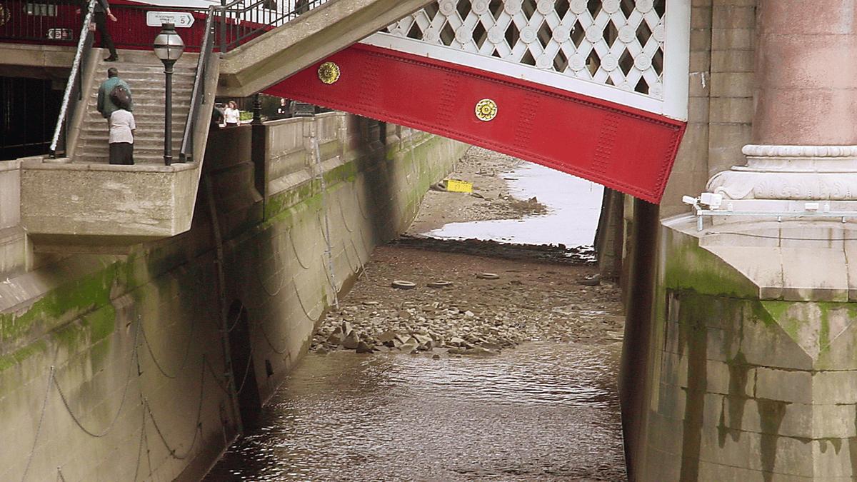
It’s at Blackfriars Bridge where our story of the Fleet ends as it meets the Thames.
Embed from Getty ImagesSir Christopher Wren, who wasn’t actually a Wren, was charged with converting the Fleet here into a place where people could live and work, a lovely canal vista.
We’re sorry to say, though, that his work failed. The Fleet became choked and no longer navigable. The remaining parts of the Fleet were covered over and it now spills into the Thames from an unassuming arch underneath Blackfriars Bridge.
It may have had its mucky moments, but it was a part of what shaped London and our rich history!
In wet weather, when the sewer system is overloaded and at very low tides, the Fleet can be seen gushing into the Thames.
The Walbrook
Let’s find the other river – the Walbrook.
In the Middle Ages, the City of London was a bustling centre of trade, with many wharves and warehouses alongside the Thames, built on reclaimed land from the river and shaping the shoreline into something we know today.
This was a busy part of the City, with hundreds of boats tied up along the numerous quays, unloading goods like grain and firewood brought down from the upper Thames area, as well as things like spices, furs and luxury cloths from the Mediterranean and the Baltic. The Thames was the gateway to the world.
On the way to the wharf, there’s some interesting things to look out for. Like the Queenhithe Mosaic that shows a thousand years of London history. It’s not just the mosaic that’s of interest, archaeological research has revealed evidence of Roman quays and a succession of medieval waterfronts, each reclaiming more land from the Thames.
Some of those wooden structures were built using timbers recycled from buildings and ships, which gives archaeologists a really good opportunity to study Saxon and medieval woodworking techniques. At low tide, you can even see some of the remaining posts which once supported quays and wharves out into the river.
Why’s it called Walbrook? The name is thought to originate from the fact the river ran through the London Wall.
Now, whilst it might be one of the shortest rivers, it was viewed as a major waterway since it carved a route right through the city.
When the Romans established Londinium, it’s likely that the Walbrook influenced their choice of location. It was an ideal transport link and water source.
The Walbrook was incorporated into a massive Victorian sewer system which by 1860 linked five main sewers, many culverts, storm sewers and sluices to create a whopping network of 82 miles of sewerage lines.
We know sewers are kind of yucky but just imagine what a gigantic engineering job that was – pretty impressive!
At 111 Cannon Street you can see the London Stone on display behind glass at ground level in the wall of the building. The London Stone is, well, pretty much what it sounds like! This stone has been the subject of various myths and legends but most likely was used by the Romans to indicate the Centre of Roman Britain, with distances in and out of London measured from here.
This stone gradually became the traditional place for swearing oaths and making proclamations, and the rebel Jack Cade is said to have struck his sword on it and declared himself mayor during his rebellion against Henry VI in 1450.
Whilst the Walbrook now exists as part of the sewer system, some lower sections remained uncovered until the late 18th century. It wasn’t just a little stream either.
Historian John Stow wrote in his Survey of London that the water had ‘such a swift course that in 1574 a lad of 18 years minding to have leapt over the channel, was borne down that narrow stream towards the Thames with such violent swiftness as no man could rescue or stay him’. It didn’t end well for the lad.
At Bloomberg Arcade at the junction of Walbrook and Cannon Street, you can find some interesting street art. It’s called Forgotten Streams. It’s by Cristina Iglasias and is a representation of what the Walbrook would have looked like using bronze and water. It’s in three parts, with other bits at the other end of the Arcade on Queen Victoria Street.
At 12 Walbrook is the Roman Temple of Mithras, built on the east bank of the Walbrook towards in the 2nd century and re-discovered in the 1950s when a new building was being built here.
The religion of Mithras or the Mysteries of Mithras as it was called, is thought to originate in Persia, a country we know as Iran. Mithraism was an ancient religion of the Persian god of light and the sun was popular among the Roman military and a strong rival to Christianity.
Legend has it that Mithras was born from a rock in a cave and was super strong. So strong that he killed a divine bull and that bull was enough to feed mankind for eternity.
It might sound pretty nutty, but Romans had strong beliefs about Gods and Goddesses and passed down many rich myths and stories, many which we know today.
Worshippers of Mithras recreated the cave by building their temples underground. It was popular with Roman soldiers and was a male only religion, shrouded in secrecy. Roman soldiers would seek valour and virility in shower-baths of hot blood from slaughtered bulls.
The church of St Stephen Walbrook originally stood on the west bank of the stream. Some say directly over the remains of the Temple of Mithras.
It was rebuilt around 1439 on the east side by which time the ground level was six metres higher, and Walbrook was no longer a stream but a street.
In 1666, the church burned down in the Great Fire of London and Sir Christopher Wren built a new church there in 1672 to replace it, which still stands. The 19 metre high dome is based on Wren’s original design for St Paul’s, and is centred over a square of twelve columns of the Corinthian order.
Embed from Getty ImagesThe Walbrook flows under the foundations of the to St Margaret Lothbury Church, as it heads towards the Bank of England. The river was buried deep underground here in 1440 under the orders, not to mention the expense, of the Lord Mayor.
The original church, like so many was damaged in the Great Fire of 1666 and was rebuilt by our old friend Christopher Wren. In the 1980s, they had to send a diver down to make repairs as the Walbrook was damaging the stonework of the church!
Explore for yourself on a City of London Walk, created with support from the City of London Corporation. Click here to find out more
Add a commentLondon’s History
London has a rich and full history that we can't wait to tell you all about! From The Romans of Londinium to the Tudors of London, it's all here.
More From London’s History